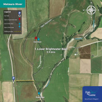
|
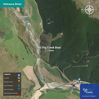
43 - Pig Creek Beat - 1.7km
To fish the Pig Creek Beat, please park next to the Fish & Game Beat sign and fish between the blue markers. Click on the map for fishing boundary details. Note: There are no beat controls beyond the upstream boundary of this beat.
|
|
|
42 - Futtah Beat - 2.2km
To fish the Futtah Beat, park next to the Fish & Game Beat sign and fish between the red markers. Click on the map for fishing boundary details.
|

|
|
41 - Upper Fairlight Beat - 5km
To fish the Upper Fairlight Beat, park next to the Fish & Game Beat sign and fish between the blue markers. Click on the map for fishing boundary details.
|

|
|
40 - Fairlight Beat - 1.8km
To fish the Fairlight Beat, park next to the Fish & Game Beat sign and fish between the red markers. Click on the map for fishing boundary details. Note: There is an Open Reach downstream, which is not subject to beat controls.
|

|
|
39 - Fairlight - Open Reach - 0.8km
An Open Reach is not subject to beat controls - normal angler etiquette applies. Simply find an appropriate parking spot and fish between the yellow markers.
|

|
|
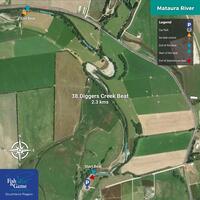
38 - Diggers Creek Beat - 2.3km
To fish the Diggers Creek Beat, please park next to the Fish & Game Beat sign and fish between the blue markers. Click on the map for fishing boundary details. Note: There is an Open Reach upstream, which is not subject to beat controls.
|
|
|
37 - Above the Brightwater Beat - 1.1km
To fish the Above the Brightwater Beat, park next to the Fish & Game Beat sign and fish between the red markers. Click on the map for fishing boundary details.
|

|
|
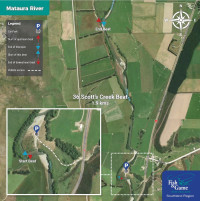
36 - Scott's Beat - 1.9km
To fish Scott’s Beat, please park next to the Fish & Game Beat sign and fish between the blue markers. Click on the map for fishing boundary details.
|
|
|
35 - Garston Bridge Beat -1.3km
To fish the Garston Bridge Beat, park next to the Fish & Game Beat sign and fish between the red markers. Click on the map for fishing boundary details. Note: There is an Open Reach downstream, which is not subject to beat controls.
|

|
|
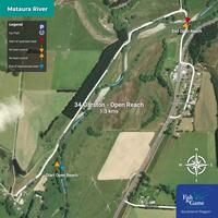
34 - Garston - Open Reach - 1.3km
An Open Reach is not subject to beat controls - normal angler etiquette applies. Simply find an appropriate parking spot and fish between the yellow markers.
|
|
|
33 - Homestead Beat - 1.8km
To fish the Homestead Beat, park next to the Fish & Game Beat sign and fish between the blue markers. Click on the map for fishing boundary details. Note: There is an Open Reach upstream, which is not subject to beat controls.
|

|
|
32 - Beehive Beat - 1.7km
To fish the Beehive Beat, park next to the Fish & Game Beat sign and fish between the red markers. Click on the map for fishing boundary details.
|

|
|
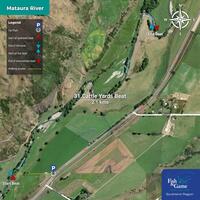
31 - Cattle Yards Beat - 2.1km
To fish the Cattle Yards Beat, park next to the Fish & Game beat sign and fish between the blue markers. Click on the map for fishing boundary details.
|
|
|
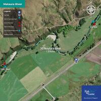
30 – Naylor’s Beat - 1.8km
To fish Naylor’s Beat, park next to the Fish & Game Beat sign and fish between the red markers. Click on the map for fishing boundary details.
|
|
|
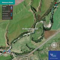
29 - Athol Bridge Beat - 2.1km
To fish the Athol Bridge Beat, park next to the Fish & Game Beat sign and fish between the blue markers. Click on the map for fishing boundary details.
|
|
|
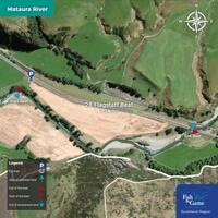
28 - Flagstaff Beat - 1.3km
To fish the Flagstaff Beat, park next to the Fish & Game Beat sign and fish between the red markers. Click on the map for fishing boundary details.
|
|
|
27 - East Road Beat - 1.3km
To fish the East Road Beat, park next to the Fish & Game Beat sign and fish between the blue markers. Click on the map for fishing boundary details. Note: There is an Open Reach downstream, which is not subject to beat controls.
|

|
|
26 - Athol - Open Reach - 0.8km
An Open Reach is not subject to beat controls - normal angler etiquette applies. Simply find an appropriate parking spot and fish between the yellow markers.
|

|
|
25 - Paddy’s Beat - 0.8km
To fish Paddy’s Beat, park next to the Fish & Game Beat sign and fish between the red markers. Click on the map for fishing boundary details. Note: There is an Open Reach upstream, which is not subject to beat controls.
|

|
|
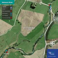
24 - Q Creek Beat - 1.7km
To fish the Q Creek Beat, please park next to the Fish & Game Beat sign and fish between the blue markers. Click on the map for fishing boundary details.
|
|
|
23 - Eyre Mouth Beat - 1.5km
To fish the Eyre Mouth Beat, park next to the Fish & Game Beat sign and fish between the red markers. Click on the map for fishing boundary details.
|

|
|
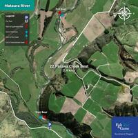
22 - Parawa Creek Beat - 2.4km
To fish the Parawa Creek Beat, park next to the Fish & Game Beat sign and fish between the blue markers. Click on the map for fishing boundary details.
|
|
|
21 - Parawa Downs Beat - 1km
To fish the Parawa Downs Beat, park next to the Fish & Game Beat sign and fish between the red markers. Click on the map for fishing boundary details. Note: There is an Open Reach downstream, which is not subject to beat controls.
|

|
|
20 - Nokomai Cabins - Open Reach - 1.6km
An Open Reach is not subject to beat controls - normal angler etiquette applies. Simply find an appropriate parking spot and fish between the yellow markers.
|

|
|
19 - Len's Beat - 1.5km
To fish Len’s Beat, please park next to the Fish & Game Beat sign and fish between the blue markers. Click on the map for fishing boundary details. Note: There is an Open Reach upstream, which is not subject to beat controls.
|

|
|
18 - Petrie’s Beat - 1.3km
To fish Petrie’s Beat, park next to the Fish & Game Beat sign and fish between the red markers. Click on the map for fishing boundary details.
|

|
|
17 - Hore's Beat - 1.3km
To fish Hore’s Beat, park next to the Fish & Game Beat sign and fish between the blue markers. Click on the map for fishing boundary details.
|

|
|
16 - Rocky Beat - 1.8km
To fish Rocky Beat, park next to the Fish & Game Beat sign and fish between the red markers. Click on the map for fishing boundary details. Note: There is an Open Reach downstream, which is not subject to beat controls.
|

|
|
15 - Nokomai Camping - Open Reach - 1.9km
An Open Reach is not subject to beat controls - normal angler etiquette applies. Simply find an appropriate parking spot and fish between the yellow markers.
|

|
|
14 - Nokomai Gorge Beat - 3.7km
To fish the Nokomai Gorge Beat, please park next to the Fish & Game Beat sign and fish between the blue markers. Click on the map for fishing boundary details. Note: There is an Open Reach upstream, which is not subject to beat controls.
|

|
|
13 - Lower Nokomai Gorge Beat - 3.8km
To fish the Lower Nokomai Gorge Beat, park next to the Fish & Game Beat sign and fish between the red markers. Click on the map for fishing boundary details.
|

|
|
12 - Upper Cattle Flat Beat - 4.2km
To fish the Upper Cattle Flat Beat, park next to the Fish & Game Beat sign and fish between the blue markers. Click on the map for fishing boundary details.
|

|
|
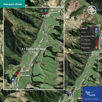
11 - Cattle Flat Beat - 3.3km
To fish the Cattle Flat Beat, park next to the Fish & Game Beat sign and fish between the red markers. Click on the map for fishing boundary details. Note: There is an Open Reach downstream, which is not subject to beat controls.
|
|
|
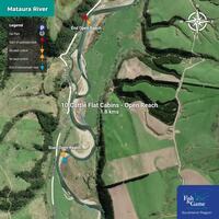
10 - Cattle Flat Cabins - Open Reach - 1.85km
An Open Reach is not subject to beat controls - normal angler etiquette applies. Simply find an appropriate parking spot and fish between the yellow markers.
|
|
|
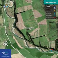
9 - Young’s Beat - 3.2km
To fish Young’s Beat, please park next to the Fish & Game Beat sign and fish between the blue markers. Click on the map for fishing boundary details. Note: There is an Open Reach upstream, which is not subject to beat controls.
|
|
|
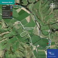
8 - Glenlapa Beat - 3km
To fish the Glenlapa Beat, park next to the Fish & Game Beat sign and fish between the red markers. Click on the map for fishing boundary details.
|
|
|
7 - Boggy Creek Beat - 2.1km
To fish the Boggy Creek Beat, park next to the Fish & Game beat sign and fish between the blue markers. Click on the map for fishing boundary details.
|

|
|
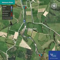
6 - The Elbow Beat - 2.5km
To fish The Elbow Beat, park next to the Fish & Game Beat sign and fish between the red markers. Click on the map for fishing boundary details.
|
|
|
5 - Sheepwash Creek Beat - 3km
To fish the Sheepwash Creek Beat, please park next to the Fish & Game Beat sign and fish between the blue markers. Click on the map for fishing boundary details.
|

|
|
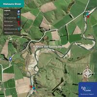
4 - Above the Tommy Beat - 4.1km
To fish the Above the Tommy Beat, park next to the Fish & Game Beat sign and fish between the red markers. Click on the map for fishing boundary details.
|
|
|
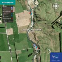
3 - Below the Tommy Beat - 1.5km
To fish the Below the Tommy Beat, park next to the Fish & Game Beat sign and fish between the blue markers. Click on the map for fishing boundary details.
|
|
|
2 - Tower Creek Beat - 1.1km
To fish the Tower Creek Beat, park next to the Fish & Game Beat sign and fish between the red markers. Click on the map for fishing boundary details.
|

|


