This district offers a wide range of fishing experiences.
Please select links to go directly to information:
Manawatu River
Mangatainoka River
Makuri River
Tiraumea River
Mangahao River
Makakahi River
Pohangina River
Kahuterawa Stream
Tokomaru River
Oroua River
Rangitikei River
Hautapu River
Kawhatau River
Moawhango River
Whakaurekou River
Manawatu River
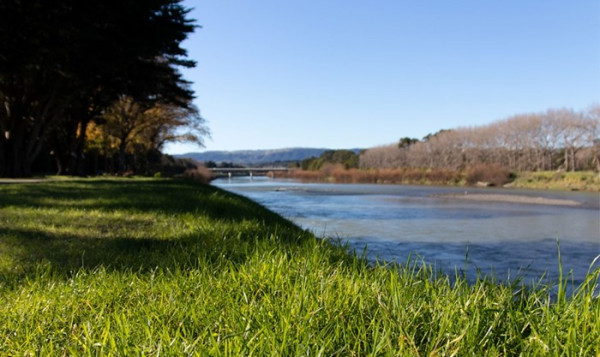 The Manawatu River has its source east of the Ruahine Range yet uniquely discharges into the Tasman Sea west of the ranges. Its 170kms of fishable water flows in a south-westerly direction beginning north of Dannevirke, past Woodville, Ashhurst, Palmerston North and Foxton. Access is readily available from a number of roads over most of its length. Almost all of the fishing is done between Dannevirke and Palmerston North. Fishing conditions vary as the river changes from a very small gravel bed channel meandering past papa cliffs, to the expansive, slow flowing and often turbid waters of the lower river. Brown trout are the mainstay of this fishery although rainbows are becoming more numerous and perch are common below Palmerston North.
Favoured fishing methods vary in response to conditions and the season. For the fly fisherman, awareness of changes in behaviour of the fish is invaluable. Early in the season the fish are forgiving, but as summer progresses and water levels fall, anglers’ patience and precision is tested. “Blind” fishing is common but many anglers relish the excitement of stalking their fish. Artificial flies should be medium to small (sizes 12-18), with common nymph and sedge patterns very popular. Throughout the season, dawn excursions often find trout cruising in the shallows. Use small caddis imitations and stalk your fish - a bank-side spotter can be invaluable. Small wet flies fished down and across are an excellent way of finding fish in the large open water.
SELECT HERE TO VIEW BROCHURE ON - Upper Manawatu River
SELECT HERE TO VIEW BROCHURE ON - Lower Manawatu River
Mangatainoka River

The river's source is in the eastern Tararua Range. It parallels SH2 flowing in a north-easterly direction toward Pahiatua. It is has about 50km of fishable water with numerous roads leading to the river off SH2, where anglers will discover the amazing number of bridges (13) which provide easy access to most of the river. The upper reaches at Putara are excellent early in the season with tantalising clear, deep pools and boulder runs. With the onset of warm temperatures, most of the trout drop back downstream. The middle and lower reaches are mostly willow-lined, similar in character, with long pools and glides interspersed with shallow riffles.
SELECT HERE TO VIEW BROCHURE ON - Mangatainoka River
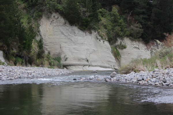
Makuri River
The river, a tributary of the Tiraumea River, is east of Pahiatua and flows in a westerly direction. Access is initially off SH2 onto the Pahiatua/Akitio/Pongaroa Road. A challenging small river rising in the limestone country of the Puketoi Ranges, the Makuri is the closest to a chalk stream we have in this region. The most easily accessible fishing is above the gorge upstream of the Makuri township. Below the township the river flows through a rugged gorge of huge boulders and fast tumbling waters. Access is difficult. From the gorge to the Tiraumea River confluence, the river flows slowly in a deeply incised channel. Fishing is often difficult so a long leader, light line and delicate presentation are the key. Both nymph and dry fly are popular with some of the larger sizes worth a try. A good caddis hatch occurs on warm evenings but the fish response is unpredictable. Morning is regarded as the best time to be on the Makuri.
Tiraumea River
The river's source is in the sandstone/mudstone hill country east of Pahiatua. It flows in a northerly direction to join the Manawatu River near Woodville. Access is initially off SH2 at Mangatainoka or Pahiatua. The least well known of the rivers in the Pahiatua region, the Tiraumea is not heavily fished. Flowing slowly through a deeply incised channel the substrate is mostly covered in sediment, although there is an extensive area of gravel near Kohinui, an area favoured by anglers. The fish have a tendency to cruise, making a careful approach to sighted fish with dry fly or an unweighted caddis nymph the favoured method. Access is not easy because of steep-sided stream banks that are often heavily vegetated.
Mangahao River
The Mangahao flows from the eastern flank of the Tararua Range in a north-easterly direction toward Woodville. Access from Palmerston North or Pahiatua (SH2) is off the Pahiatua Track road. It is an attractive river to fish although as a comparatively steep river, its highly varied flows produce inconsistent numbers of fish. The best fishing is early in the season and a mild stable winter seems to encourage trout to remain in the river. De-silting of the dams in the headwaters occurs in March with the river unfishable for some time until it clears. The upper reaches within the Tararua Forest Park produce few fish, usually large jacks.
Makakahi River
This river drains from the eastern Tararua Range and flows in a north-easterly direction toward Pahiatua. It parallels SH2 and is accessible off this highway for all of its length. Most fishing is focused on the 30km or so between Eketahuna and its confluence with the Mangatainoka River. Upstream of this point the fishing tends to be patchy, with the early season favoured. The flow is often gentle, with few riffles and as a result the fish tend to cruise, seldom holding stations. For anglers who like to poke around among the willows intercepting cruising fish, it's an ideal piece of water. A careful approach and presentation is needed. Casts are usually short and often the fly can just be dropped below the rod tip from in among the willows.
Pohangina River
This river has its source on the western flank of the Ruahine Range and flows southward to join the Manawatu River at Ashhurst. Access initially is off SH3 onto Pohangina Road and then either Pohangina Road East or Pohangina Road West that parallel the river for 40km or so. It's a relatively unstable river in a wide channel with extensive gravel beaches. There are good trout numbers along the length of the river, but fluctuating on the frequency and severity of flooding. Popular locations are either adjacent to the bridge at Raumai, where a picnic area provides easy river bank access, or Totara Reserve, a further 10km upstream. Natural barriers to upstream fish movement means there are few fish, if any, within the Forest Park. It is a river best suited to sight fishing although nymphing, spinning or bait fishing the fast water in runs or the heads of pools, is worth trying.
SELECT HERE TO VIEW BROCHURE ON - Pohangina River
Kahuterawa Stream
A picturesque small stream near Palmerston North, the small pools and bubbling rapids can provide an enjoyable day’s fishing. The Kahuterawa can hold resident fish throughout the summer but as a spawning tributary of the Manawatu, more consistent success will be achieved either late or early in the season, when pre or post-spawning fish are in residence. Access is off Old West Road behind Massey University.
Tokomaru River
The Tokomaru River rises on the western side of the Tararua Range and flows westerly to cross SH57, between Palmerston North and Shannon. The headwaters provide mountain style fishing in high quality surroundings for good sized but few fish. It is a rugged area with deep pools and numerous large boulders making progress very difficult in places and is only recommended for fit anglers. Fly-fishing is the most productive method. Access to the upper reaches is via the Horseshoe Bend Recreation Reserve off Tokomaru Road. This area is not included within the Forest Park and permission is required. Downstream of SH57 fishing can be rewarding with a little patience and careful stalking. It is best fished early in the season and landowner permission is required.
Oroua River
The Oroua exits the western Ruahine Range at Apiti to flow southward through Feilding. Into the ranges access, off the end of Table Flat Road, is reasonable, and, for the moderately fit angler, the fishing is very enjoyable in scenic and peaceful surroundings although trout numbers are generally low. Downstream to Kiwitea, access is off Oroua Valley and Kimbolton Road. The fishing is fair to good depending on the frequency and severity of floods. Downstream of Kiwitea to Feilding access is of Kimbolton Road and the fishing is variable but generally poor. Below Feilding, access is off Awahuri Road, and while the fishing is good it is best in late winter to early summer before the effects of low flows and waste discharges make it an unattractive proposition.
Rangitikei River
The Rangitikei River has its source in the Kaimanawa Ranges, east of Lake Taupo and flows southward to the Tasman Sea about 50km south of Wanganui. Most of its 241km length provides good to excellent fishing ranging from trophy rainbow and brown trout in wilderness surroundings to estuary dwelling sea-runs. Access to the headwaters is best via helicopter although for the very fit angler there is a track leading off the Desert Road which takes 10-12 hours. The many kilometres of accessible middle and lower reaches are the most popular with year round fishing available. Access is readily available with many roads leading off SH1. Rainbow trout movement through the system has a major influence on fishing success. Typically mature fish move upstream during late autumn early winter, leaving behind good numbers of one and two-year old fish that are ideal for winter fishing. Brown trout are more evenly distributed throughout the river, although mature fish are less available during the winter. Spin fishing is very popular, particularly with “Veltics”, “Dandy’s”, “Rapala’s” and “Z” spinners. When fly-fishing, with either wet-fly or nymph, it is critical to get your fly to the feeding depth of the fish.
SELECT HERE TO VIEW BROCHURE ON - Rangitikei River
Hautapu River
The Hautapu River is unique insofar as its origins are in comparatively unmodified low, rolling tussock country east of Waiouru and not from a mountain range as is the case with most of our river fisheries. It is also unusual in that it is comparatively small and contains good numbers of comparatively large brown trout and is managed as a “trophy” fishery. Access is mostly off SH1, which tends to follow the river and angler access along the majority of the river is public although this is erratic. The river channel is not wide, carries a good stable flow and is tricky to negotiate. The water is, at best, slightly turbid so patient stalking is required unless fishing “blind” the many turbulent bouldery runs. From December on, trout will rise quite freely on warm days and large dry-flies work well.
Kawhatau River
This river runs off, at a fair pace, the western Ruahine Range to meet the Rangitikei just upstream of Mangaweka. Access is off SH1 at Mangaweka, across the Rangitikei River, and then up the Kawhatau Valley Road. Whilst there is evenly spaced access to the river at road bridges, an approach to landowners can be rewarding for access between the bridges. It is a generally unstable river with fish numbers fluctuating and is therefore infrequently fished. Best in either spring or autumn with all methods, depending on river conditions.
Moawhango River
The Moawhango River’s headwaters are east of Waiouru within the NZ Defence Force Army Training Group area. The river flows in a southward direction to join the Rangitikei east of Taihape. A dam, built in 1979, truncates the headwaters diverting these to the Tongariro River leaving the river a shadow of its former self. It is, mostly, a deeply incised river particularly in the lower reaches where angler access is very difficult to impossible. Access to the river below Moawhango village is reasonable as roads parallel the river; upstream though landowner permission is required. Not a well known river to anglers because of the difficulties with access; anglers need to be fit, good at cliff scrambling and occasional deep river crossings. The river, since being diverted in the headwaters has changed from a predominantly rainbow fishery to a brown trout one and generally, good numbers of these can be found. Turbid water can be a problem to the angler when rain falls in the catchment as the Moawhango discolours quickly. Spin fishing is not a practical option and even bait fishing is limited leaving fly fishing a nymph or dry as the preferred method. Trout rise freely on warm summer days.
Whakaurekou River
This river joins the Rangitikei east of Taihape after running off the steep slopes of the western Ruahine Range. Access is either via the Rangitikei River walking upstream from Mokai off the end of Mokai Road (landowner permission required and the river must be low) or via private farm access off Pukeokahu Road opposite the confluence with the Rangitikei. Often unstable, fish numbers can vary greatly from year to year. It is one of the most scenic small river fisheries in the district. Best fished early or late in the season.