To view the access map and brochure click on Mohaka River
1 - Poronui Station Poled Access
A poled public walking route to the Mohaka River starts at the end of Taharua Road which is accessed off SH5 near Rangitaiki. The land adjacent to the track is privately owned and should not be crossed. It is a 9km walk to the river. The alternative is to fly into one of the private airstrips or the Department of Conservation (DOC) helicopter pad at Oamaru hut. The Oamaru and Kaipo Rivers meet at this point to form the Mohaka River. The public access continues downstream of the confluence for approximately one kilometre on the true left bank.
2 - Blue Gums or Hot Springs
DOC Kaweka Forest Park. Drive via Puketitiri, Pakaututu and Makahu Roads to the Blue Gums/Hotsprings road end. The Te Puia hut track provides good walking access to the upper reaches including the Makino River. The hut is approximately three hours walk from the carpark (camping is permitted).
3 - Makahu River
The Makaha River is crossed on the way to the Blue Gums/Hotsprings. Please contact Oliver Nicholas (Ph 06-839-8629) for permission to fish the Makahu either upstream or downstream from this point. No dogs or firearms.
4 - Pakaututu Bridge
This gives good access to the Mohaka River at this point. A strip of public land on the true left bank leads downstream to the Ripia River confluence and up the true right bank of that river for approximately 10km.
5 - McVicars Road Bridge
Turn onto McVicars Road from SH5 on the Taupo side of the river. About 3km along this road you will reach the McVicars Road bridge. A strip of public land on the true right bank provides access both - upstream and downstream from this point.
6 - McVicars Road
Approximately 1km from SH5 a metal vehicle track leads off to the left and down to the river. Further along the road, near the confluence with the lnangatahi Stream, there is an esplanade reserve on the true left bank.
7 - Glenfalls Recreation Reserve
Good access and camping is available at this Department of Conservation reserve alongside Waitara Road, 6kms from SH5.
8 - Jock Sutton Road
This Panpac Forestry road leads off Waitara Road and provides public access to the Mohaka River opposite the Waipunga River junction. Camping is allowed on the riverbank. The road can be closed for forestry operations or at times of high fire risk. Please drive with lights on for safety reasons. No open fires permitted.
9 - Glenfalls Forest (Auroa Road)
Off Waitara Road, this Panpac Forestry road provides public access to about 5km of river. A number of grassed sites are available for camping. Take care with the ford over the small creek which is normally passable in a car. This road can also be closed for the same reasons as 7. Please drive with lights on for safety reasons. No open fires permitted.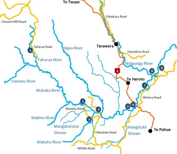
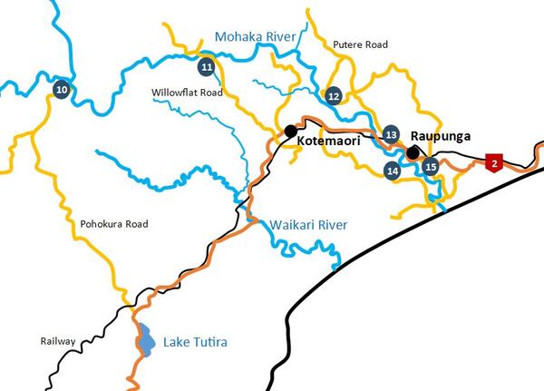
10 - Te Hoe Junction
The site is accessible from both SH5 via Waitara Road and SH2 via Pohokura Road (Tutira store turnoff). The end of Pohokura Road passes down through Waitere Station to opposite the Mohaka River junction with the Te Hoe River. The true right bank of the Mohaka is accessible from this point. Cross the Mohaka with considerable care. The Te Hoe flows over Crown river bed. You can walk upstream as long as you stay within the river.
11 - Willowflat Road Bridge
Turn off SH2 just south of Kotemaori. Access to the river is possible from the road bridge.
12 - Patuwahlne Road
This forestry road leads steeply down to the river and in wet conditions is only accessible by four wheel drive vehicle. Turn off SH2 at Raupunga on to Putere Road and Patawahine Road is approximately 10km on the left.
13 - AH2 Bridge
A parking and picnic area on the true right bank provides access to a short stretch of river.
14 - SH2 Access
Approximately 1km north of the SH2 bridge an unnamed gravel road on the right leads down to the Mohaka River. It is possible to park close to the edge of the water and fish about 1km of river. Not a well recognised spot but worth a go.
15 - Mohaka Township Road
This road provides access to the river mouth and the road bridge 1km upstream from the mouth. Some good sea run fish use this reach, particularly late in the whitebait season (November).
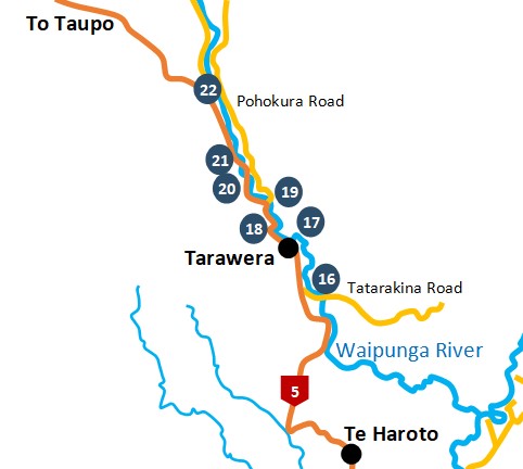
16 - Tatarakina Bridge
The road to Tataraakina Station and the Waipunga River turns off SH5 about 5km south of the Tarawera Tavern. Because of the steep nature of the river channel and thick bank vegetation, only about 1km of river is fishable from this point.
17- Tarawera Hot springs
The access track to the hot springs and adjacent river heads north from the Tarawera Tavern carpark. Please leave gates as you find them. Approximately 2km of river is reasonably accessible from this point.
18 - 21 State Highway 5
SH5 follows the river which can be accessed from a number of points. Note that these points are adjacent to SH5 and considerable care should be exercised when parking in this area.
22 - Upper Waipunga
Turn right onto Pohukura Road after passing the Waipunga Falls lookout area when travelling from Napier. Then turn onto Waipunga Road. Above the falls the river supports only brown trout. An access permit is needed. Phone: 07-350 1234 or 07-366 1000.